


Tabiat Bridge that is also called Nature bridge, is one of the tourist hubs of Tehran, which has been very popular in the past years and has become one of the symbols of Tehran. The most amazing thing about Tehran’s Tabiat Bridge is that although it is located between several major highways in this city and is built just in the center of crowds and traffic, it brings a sense of being in Tabiat and breathing. The presence of green spaces, walking paths and seeing people with energy and happiness who come to Tehran Tabiat Bridge for fun or sports, doubles the feeling of freshness and vitality of this space.

Tabiat Bridge Structure
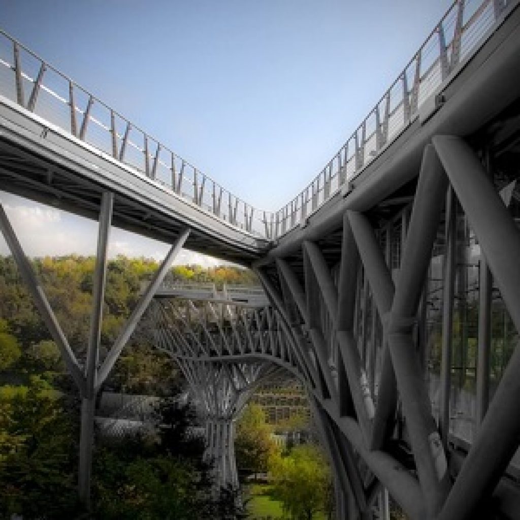
The Tabiat Bridge, is Iran’s largest bridge That car does not pass over it, with an area of 7,000 square meters and a weight of 2,000 tons, is located on the Modares Highway and connects Taleghani Park in the east and the Water and Fire Park in the west. The bridge was designed by Leila Iraqi and in collaboration with Ali Behzadian. Leila Iraqi, the designer of the Tabiat Bridge, was only 26 years old when she designed it. The Tabiat Bridge is built as a three-dimensional truss with a dynamic form on two interconnected surfaces. The truss rests on three pillars with a tree-like shape. The main body of the bridge is built on a tripod, which is made of 14,000 steel pieces. For the construction of this bridge, more than 102 km of welding and 6200 cubic meters of concreting have been done.
This recreational bridge is 270 meters long and is built at a height of 40 meters above the ground. Its openings from east to west are defined as 68 meters, 94 meters, 68 meters and 39 meters, respectively. The width of the bridge also varies between 6 meters and 13 meters. The entrance from Taleghani Park to the Tabiat Bridge is accessed by stairs that comes from the lower park’s trees and reach the bridge. The entrance to the Water and Fire Park is also a 40-meter-wide entrance square that has been opened to protect trees.
walking trails
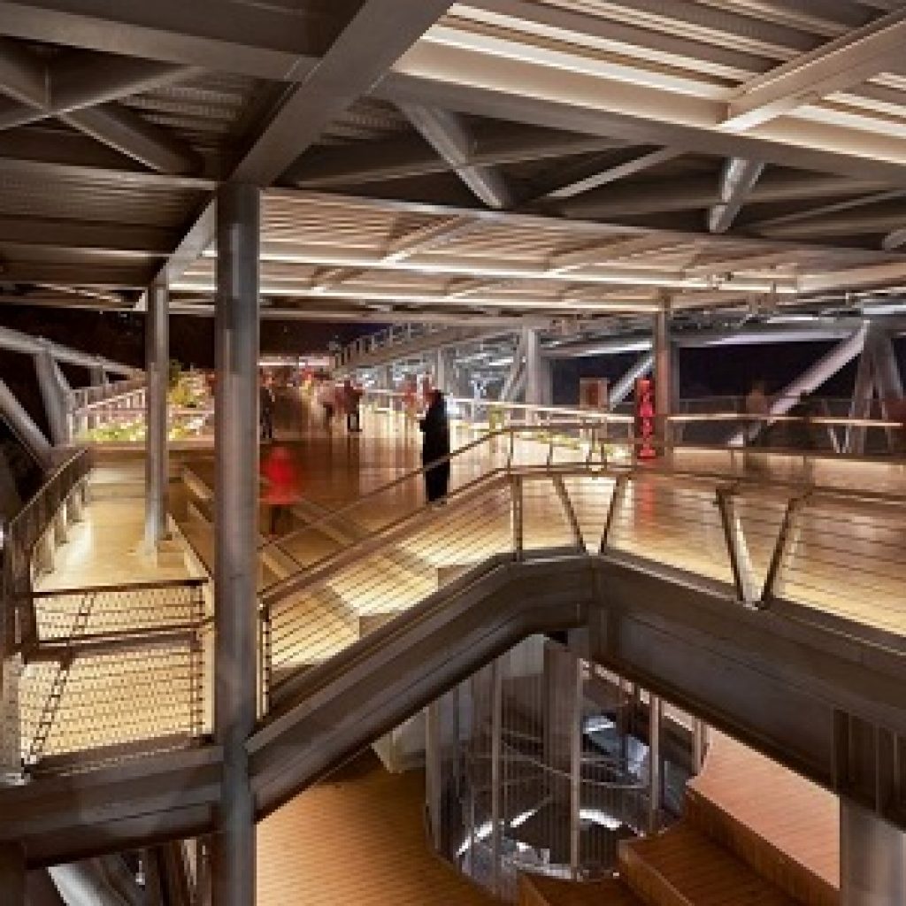
This Bridge has three levels that are connected by several stairs.
The first level, from both the Water and Fire Park and the Taleghani Park, has two entrances, one on the side of the Taleghani Park, a gallery coffee shop and one on the side of the Water and Fire Park, there is a restaurant with more spaces for recreation and sitting.
The second level, one floor higher, is designed for walking, cycling and stroller. Despite the mobility, there is plenty of green space and seating at this level.
The third or highest level was later added to the bridge and was not in the original design. As its architects have emphasized, the third level has spaces to stay. This means that it has several benches and places to sit and relax.

Landscapes of the Tabiat Bridge
Beautiful views of Taleghani Tabiat Park, Sea Lantern of Park Ports, Ports of Fire towers in Ibrahim Park, Gonbad Mina, the world’s third largest flag in Taleghani Park, the southern slopes of Alborz Mountain and Damavand Mountain, and highways such as Modares, Haqqani, Hemmat and Resalat are visible on Tabiat’s bridges.
On the bridge of Tabiat, you will have a lot to eat and drink. You can use the restaurants of the Tabiat Bridge, and go to the various cafes and food courts on the bridge. The positive feature of these restaurants is that in most of them, while enjoying your tea, drink or food, you can also enjoy the beautiful views of the bridge.

Design Awards
Design of Tabiat Bridge Structures in addition to numerous awards dedicated at domestic conferences and festivals in Iran, also dedicated to itself IPMA International Silver Awards for Project Management (Panama), MEIDAA in the Middle East Public and Urban Projects Project (Dubai), Award + A Architizer is also part of the Bridge and Highways (New York) section.
Cost and time table to visit Tabiat bridge
Ticket price: free
Opening hours: 6:30 – 24:30
English and Farsi address of Tabiat bridge
Tabiat bridge, Modarres highway, Tehran
تهران، بزرگراه مدرس، پل طبیعت

